
Research Experience for Teachers (2018-2019)
Save the Soil!
 |
||||||
|
||||||
Keywords:
|
|
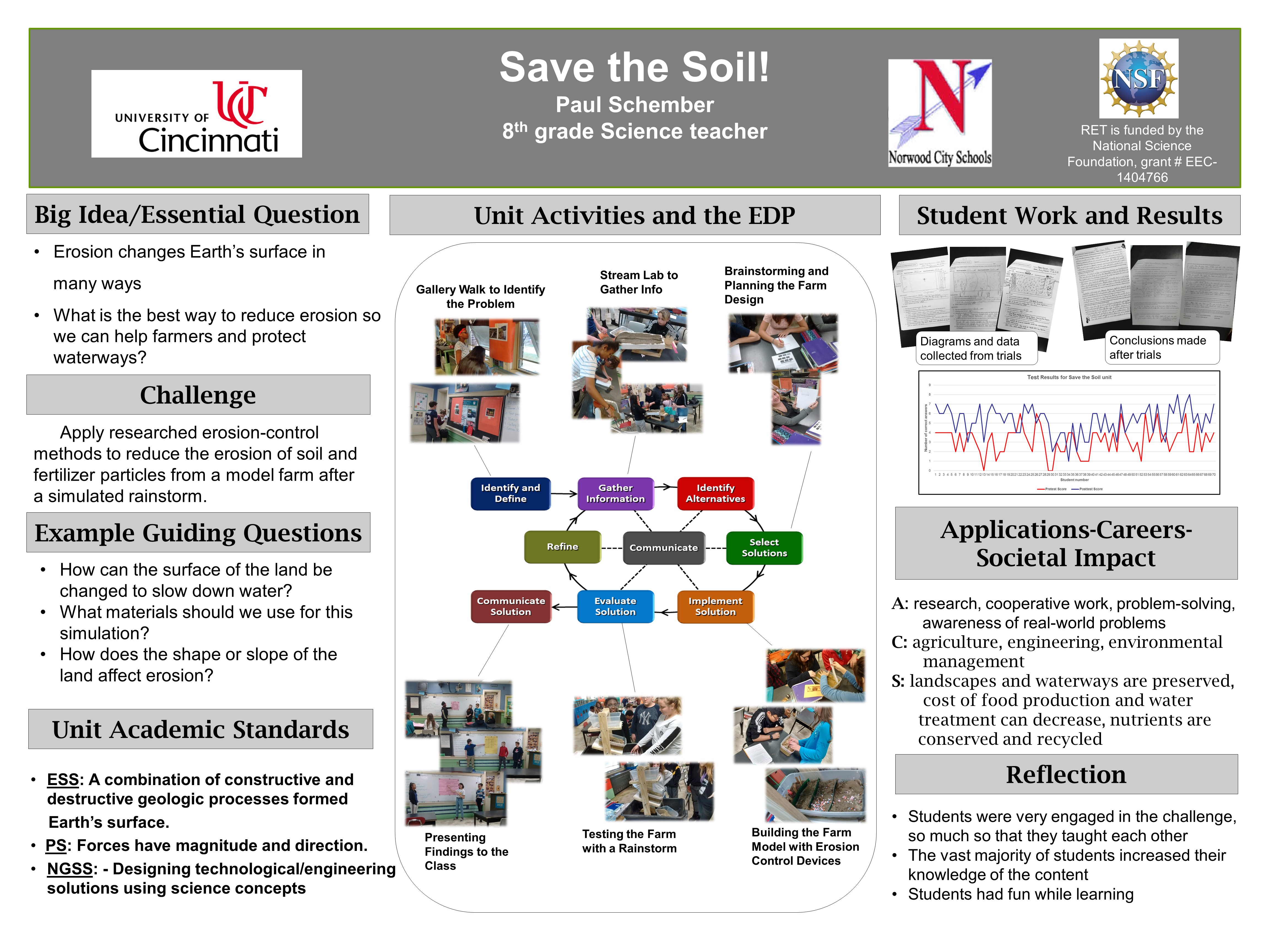
The Big Idea (including global relevance) Minimizing erosion: Erosion is constantly changing Earth’s surface by moving sediments and soil to new places by the forces of wind, water and gravity. Erosion is a problem for people farming on land with a slope because their valuable topsoil gets eroded downhill. When the good soil with all of its nutrients is removed, this leaves poor soil that farmers must add fertilizers (usually in the form of chemical pellets) to the land in order to improve its ability to grow crops. As the erosion process continues each year, the fertilizers from the fields get washed into the watershed and can trigger eutrophication in bodies of water when nutrient levels reach critical levels. By minimizing erosion on farmland, the rich soil is kept in place, extra chemicals are not needed, and eutrophication is avoided. |
|
Essential Questions
|
|
The Hook
|
|
The Challenge A nearby community contains a lake that is fed by the watershed surrounding it. That lake is used by the residents for recreational activities such as swimming, boating and fishing. Lately, the water has been plagued by toxic algal blooms that prevent people from using the lake. Meanwhile, farmers who live near the lake have been complaining about the high prices of fertilizer pellets and how they keep losing some of their best topsoil every year. Your challenge is to help the farmers and the community by finding a way to keep the topsoil in the farms so that it doesn’t pollute the lake with chemicals that feed the algae. This will also help to make the lake useable again! |
|
Guiding Questions
|
ACS (Real world applications; career connections; societal impact)
This challenge strongly applies to the real world because erosion due to runoff on sloped land happens anywhere in the world where rainfall and watersheds exist.
Societal impact will be emphasized during the testing phase of this challenge as students see how much erosion happens to a plot of land that is inhabited by people. The implications of that erosion (groundwater pollution, crop failure, habitat loss, structural failure of houses and other buildings, etc.) will be discussed and learned.
- Environmental engineers- students will be introduced to this career during the challenge as they conduct and investigation and work as “junior engineers” who are finding and modeling solutions for a client
- Farmers- this career will be explored briefly as the client needing the engineers’ help; students will learn about practices farmers can use to prevent erosion.
- The erosion control practices mentioned above might also apply to careers such as excavators, land developers, and forestry/wildlife management personnel.
Misconceptions
Unit Lessons and Activities
- Lesson 1: This lesson will focus on getting students interested in the content related to erosion, generating essential questions and a challenge question, and then providing experiences that teach students about erosion so that they can use the information to succeed in the challenge.
- Activity 1: Introducing the Unit: A Gallery Walk, Erosion Relay race, Video clip, Generating the Essential Question, Challenge and Guiding questions (2 days)
- Activity 2: Stream Lab, Interactive lab investigation website for erosion on a hill (2-3 days)
- Lesson 2: This lesson will focus on learning more content about erosion and then researching for specific practices that can be used to prevent or reduce erosion. Students will then use information learned to build a model that makes use of their findings to satisfy the challenge requirements. After three iterations, student groups will communicate results to their classmates.
- Activity 3: Notes and/or video with supporting questions to add content for weathering, erosion, and deposition (1 day)
- Activity 4: EDP, Research erosion mitigation techniques, Brainstorming and planning activity, Building and testing models, Presenting best solution and data to class, Posttest (4-5 days)
- Evidence of CBL: Lesson 1, Activity 1 and Lesson 2, Activity 4
- Evidence of EDP: Lesson 2, Activity 4
Additional Resources
Materials used in Challenge:
- Per student group
- Sterilite 6-quart tote box with 4 drain holes (3/4”) drilled at one end
- Two pounds of gravel added to each tote to simulate bedrock
- Layer of clay pressed in on top of gravel to represent clay layer under soil. Each box had clay added until it weighed 7.5 pounds. This brought the clay level up to the bottom edge of the drain holes in the end of the box.
- Enough moist sand to bring the total weight of the tote to 12.5 pounds. This filled the tote to a level higher than the tops of the drain holes.
- Three plastic farm animals
- Popsicle sticks cut in half to be used as fenceposts to indicate area for animals
- One cup of shredded dry sphagnum moss to mix into the sand if the group desires to use no-till version of soil.
- Copy of all documents used during the challenge: Procedures, Data packet, Research worksheet, Conclusions sheet, etc.
- For the whole class
- A variety of materials to be used as scale models of the various erosion control methods on the farms:
- silt fences made of window screen cut to fit at end of box
- mulch made of chainsaw shavings, applied on surface of sand
- perforated drain pipes made of drilled 3/8” pipes with ¼” holes and wrapped in tulle; buried in the sand
- wattles made of peat moss rolled up in mesh material, held in place by toothpicks
- geotextile made of window screen cut to fit over the crop area of the sand and held by toothpicks
- terrace walls made of stiff plastic strips cut from 2 liter bottles or milk jugs and held in place by toothpicks
- vegetated waterway fabric made of tulle strips and held in place with pins
- diversion structures made of 2 inch x 1 inch pieces of stiff plastic held upright by toothpicks
- A 6-quart tote with tiny holes (1/64”) drilled to act as the rainmaking device
- A stand for holding the farm at an angle while the rain falls on it
- A large basin (concrete mixing tub) to set the stand inside of
- 8-quart totes for catching the runoff from the farm during the rainstorm
- Aquarium nets for scooping out floating debris from the runoff
- Cloth sieves for separating the sand from the runoff.
- several five-gallon buckets for runoff separating and sand storage
- Digital postal scale for measuring farms during setup and for measuring the sand in the runoff.
- Measuring device capable of holding 1200 ml of water for the rainstorm trials
- Sieves made with window screen for sifting debris out of the sand if the sand is to be reused another year.
- Mini-bale of dried sphagnum moss
- A variety of materials to be used as scale models of the various erosion control methods on the farms: